IntroductionHawai`i Volcanoes National Park became America’s 13th National Park on August 1, 1916. The park is a unique geographical landscape located primarily in the Ka‘ū and Puna districts on the southeastern slope of the Big Island (refer to Figure 1). Hawai`i Volcanoes National Park encompasses a little over 505 square miles of federal land which includes Mauna Loa, the world’s largest volcano and one of the world’s most active, Kilauea. The dramatic elevation change within the park results in substantial climatic variations occurring in a relatively small geographic area.
In general, the temperature on the Big Island decreases 5 degrees Fahrenheit for every 1,000 feet gained in elevation. The National Park Service recognizes seven biomes within the park's boundary. These include seacoast, desert, lowlands, mid-elevation woodlands, rainforest, upland forest and alpine. These ecological habitats are greatly influenced by the easterly trade winds. Moist air is forced up the southeastern slopes of the Big Island, creating a rain corridor which ultimately helps shape the diverse ecosystems found here. Elevation is the primary factor in determining precipitation. Coastal regions in the park receive rainfall accumulations of only 20 inches per year while mid-altitude areas can receive over 144 inches per year. During times of volcanic eruptions, sulfur dioxide emissions create blankets of acid rain which suffocate all vegetation growth in the surrounding lava flows. The physical geography and climate characteristics occurring in Hawai`i Volcanoes National Park create a diverse sanctuary for a variety of flora and fauna. Over the past 70 million years, volcanic activity has been shaping the physical environment of the Hawaiian islands. Hawai`i Volcanoes National Park is literally a hot spot for volcanic processes on the Big Island. Historically, the park has experienced substantial lava flow from two pit craters, Mauna Ulu and Pu'u ō’ō, both located on the east rift zone of Kilauea (refer to Figure 2). |
From 1969 to 1974, lava gushed from Mauna Ulu’s cinder cone blanketing large portions of the Chain of Craters Road, Nāpau Trail, Nāulu Trail and the Puna Coast Trail (refer to Figure 14). Currently, Volcanoes National Park is experiencing gradual surface flows from fissure eruptions on the southeast flank of Pu'u ō’ō's cinder cone. Surface flows began at Pu'u ō’ō in January 1983 and new fissures have since developed in areas east and west of Pu'u ō’ō's crater. According to the National Park Service in 2011, since January of 1983, Pu'u ō’ō has created over 700 acres of new land, flattened 200 homes, covered 7 miles of highway and buried numerous heiaus and archeological sites within the boundary of the park. The violent yet beautiful interactions between lava and earth are displayed by the seemingly endless supply of cinder cones, pit craters and volcanic features scattered throughout Hawai`i Volcanoes National Park.
Day 3 Arrival October 23, 2011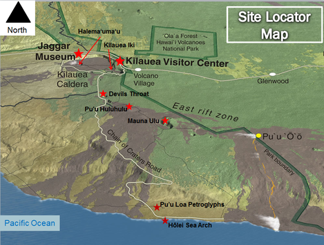 Figure 2. Regional map of park boundaries, includes features of interest and our stops during the day. Illustration by USGS. (Map by Sam Krueger)
We arrived at Hawai`i Volcanoes National Park on the morning of Sunday, October 23. Our first stop in the park was at the Kilauea visitor center. After filling our canteens with natural spring water, we oriented ourselves during a ranger tour and then took off on the Chain of Craters Road traveling 23 miles and descending 3,700 feet over the Hōlei Pali to the coast. The Chain of Craters Road which was originally constructed in 1928 was further extended in 1959 to reach the town of Kalapana. However, decades of active lava flows from Pu'u ō’ō have since wiped out approximately 7.5 miles of highway, making the cities of Hilo and Kalapana currently inaccessible from the Chain of Craters Road. Along this route we observed numerous volcanic features both physical and cultural in nature. Refer to Figure 2 for the sites that will be discussed in further detail in Day three.
|
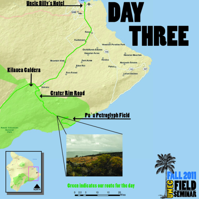
Figure 1. Locator map showing our route during Day three of our trip to Hawai`i Volcanoes National Park, also includes major points of interest. (Map by Jon Bowen)
Sources
USGS. Hawai`i Volcanoes National Park. Kilauea Summit Area. Retrieved December 19, 2011 (http://www.nature.nps.gov/air/webcams/parks/havoso2alert/havosummitarea_lg.cfm)
2011. “Hawaii Volcanoes National Park Hawaii.” National Park Service US Department of the Interior. Retrieved November 16, 2011(http://www.nps.gov/havo/index.htm).
Banner photo by Shandi Siegl
2011. “Hawaii Volcanoes National Park Hawaii.” National Park Service US Department of the Interior. Retrieved November 16, 2011(http://www.nps.gov/havo/index.htm).
Banner photo by Shandi Siegl
