Stop 2 Kilauea's Summit CalderaFrom the visitor center, we hiked along a small dirt path until we reached a clearing just before the summit caldera. The view was simply breathtaking. We were immediately greeted by panoramic views of the caldera and surrounding landscape. As we approached the aged wooden railing dividing us from the 270 foot drop below, we carefully peered down to observe the contents of the crater. Kilauea’s summit caldera measures 1.8 miles long by 3.1 miles wide.The caldera formed from a violent explosion in 1790 which collapsed the shield volcano's summit. Collapsed walls and landslides are some of the most apparent physical features, many of which are located along the northeast rim. The steepest sections of the caldera's rim are located on the southwest wall, likely resulting from the 1924 eruption of Halema‘uma‘u, the comparatively smaller pit crater located inside Kilauea’s summit caldera (refer to Figure 6).
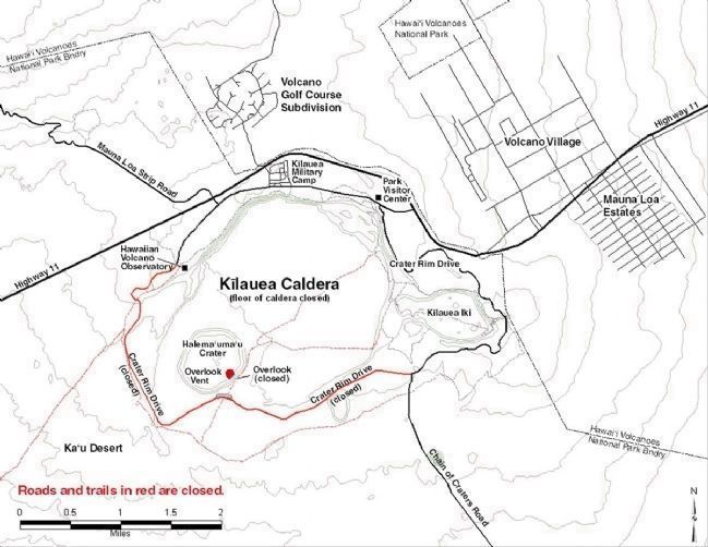
Figure 6. Aerial site locator map showing the Kilauea summit, Halema‘uma‘u and Kilauea Iki. (Illustration from Steph Hicks)
Significance of Halema‘uma‘u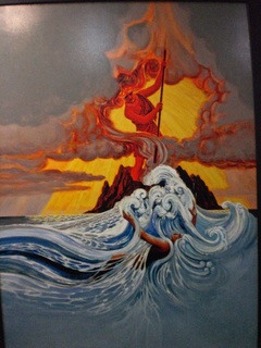 Figure 7. Pele (Photo by Ellen Sorenson)
Sitting nearly 300 feet below the southwest corner of the summit caldera lies Halema‘uma‘u, an active pit crater of great cultural and physical importance to the landscape of Hawai`i. Halema‘uma‘u holds great mana or "power" in Hawaiian mythology. This is the home of Pele, the Hawaiian goddess of fire, volcanoes, lightning and wind, (refer to Figure 7). Kilauea is thought to be the body of Pele and Halema‘uma‘u was her place of sanctuary. Halema‘uma‘u is Hawaiian for “House of the ‘ama‘uma‘u fern.” The origins of the name can be traced back to the mythological battle between Pele and the rain god Kamapua‘a. In this ancient Hawaiian myth, Kamapua‘a realized Pele was not able to create lava flows at will and in turn covered the opening of Halema‘uma‘u with various ferns and green vegetation. Pele began suffocating from the smoke build up and was forced to surface from the crater. A truce was called between the two gods and after a deal was discussed, the island was divided. Pele was granted the much drier leeward side while Kamapua‘a received the windward side. The cultural importance of Kilauea and Halema‘uma‘u are still evident today as spiritual gifts are routinely offered to Pele's sanctuary.
Gaseous PhenomenaIt was hard to ignore the two gaseous phenomena occurring during our visit to the Kilauea caldera. It all began during a 2008 eruptive event within the core of Halema‘uma‘u causing a continual blanket of sulfur dioxide gas release. The March 2008 eruptive episode marked the first activity of vog (volcanic smog) and lava since 1924. This would only be the fourth eruptive event in Halema‘uma‘u's history! Second, steam plumes were quite evident throughout the park, especially around the east rim of the caldera. When groundwater seeps onto hot volcanic rock, steam plumes rise as a result. Steam plumes differ from sulfur dioxide in chemical content and physical appearance. Sulfur dioxide is thicker and rich in carbon dioxide, sulfur dioxide and hydrogen sulfide. Together, these gases give off the classic “rotten egg” smell we are all familiar with. Steam plumes however appear hazy and are the gaseous form of water vapor. One should take note of the differences in gases as sulfur dioxide is extremely harmful to those with health conditions where as steam plumes are relatively harmless. For updated reports on trail and park closures please visit the Hawaiian Volcano Observatories daily update provided by the USGS.
|
Kilauea Iki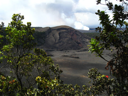 Figure 8. The Kilauea Iki cinder cone resulted from the violent eruptions of 1959. Pu`u ō`ō can be seen smoldering in the background. (Photo by Beth Amann)
Before heading further down the Chain of Craters Road we made one final stop at the Kilauea Iki pit crater located just east of the summit caldera, (refer to Figure 6). Figure 9 illustrates the eruptive phases Kilauea Iki underwent during its violent but short eruptive period Nov. 14 through Dec. 20, 1959. This event was triggered by a series of deep and shallow earthquakes that propelled magma into Kilauea Iki’s underground magma chamber.
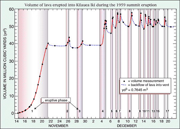
Figure 9. From Nov. 14 through Dec. 20, 1959 Kilauea Iki experienced 17 eruptive episodes of varying discharge. This short but explosive event formed the present physical landscape of Kilauea Iki. (Figure by Richter)
Lava eruptions, fountains and fissures created a new cinder cone within Kilauea Iki called Pu`u Pua`i, or “gushing hill.” The fragile walls of Pu`u Pua`i frequently cracked and fell into the lava lake forming below the cinder cones summit. Of the 17 eruptive phases, phase 3 proved the most explosive. The greatest quantities of spatter and pumice were generated during the Nov. 28 through Nov. 29 eruptive phases and pumice fragments from this event were found over 10 miles away (USGS, 1999). The Pu`u Pua`i lava lake depth fluctuated throughout the 1959 eruptive episodes but on Dec. 11 a maximum depth of 414 feet was reached. The greatest lava flow occurred during the 12th eruptive phase when Pu`u Pua`i spewed a recorded 1.45 million cubic meters per hour for two entire hours!
Kilauea Iki experienced large exchanges of lava flow between the summit magma reservoir and the summit caldera. As documented by the USGS in 1999, Figure 10 illustrates the net lava flow through all eruptive phases of the Kilauea Iki eruptions. It's interesting to note that compared to all 17 eruptive events, episode 1 experienced the highest deposit of magma into the summit caldera from the magma chamber below. This result is an outcome of the length and explosive attributes during phase 1 (refer to Figure 9). 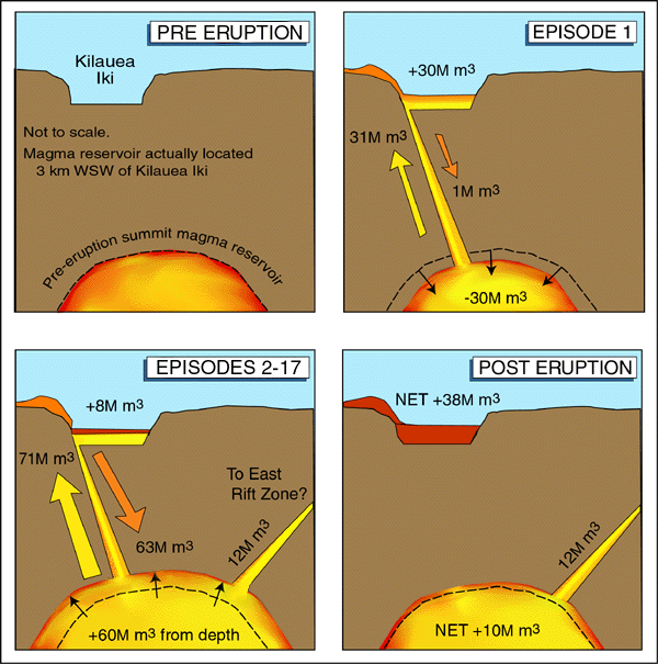
Figure 10. Net lava flow throughout the eruptive phases of Kilauea Iki. (Illustration by J. Johnson)
|
Sources
2011. “Area Closures and Advisories.” National Park Service US Department of the Interior. Retrieved November 15, 2011. (http://www.nps.gov/havo/closed_areas.htm).
Hicks, Steph. "Hiking Through a Hawai`i Volcano Crater." Hubpages. Retrieved December 19, 2011 (http://stephhicks68.hubpages.com/hub/Kilauea-Volcano)
Johnson, J. 1999. “Magma Budget For Kilauea Volcano's Summit Reservoir During Kilauea Iki's Eruption.” USGS Hawaii Volcanoes Observatory. Retrieved November
15, 2011. (http://hvo.wr.usgs.gov/kilauea/history/1959Nov14/MagmaBudget.html).
Richter, D.H., Eaton, J.P., Murata, K.J., Ault, W.U., and Krivoy, H.L., 1970, Chronological narrative of the 1959-60 eruption of Kilauea Volcano, Hawaii: U.S.
Geological Survey Professional Paper 537-E, 73 p.
1999. “Summit Eruption of Kilauea Volcano, In Kilauea Iki Crater, November 14th - December 20th 1959.” USGS Hawaii Volcanoes Observatory. Retrieved
November 7, 2011 (http://hvo.wr.usgs.gov/kilauea/history/1959Nov14/).
1999. “Tour of the Summit Caldera.” USGS Hawaii Volcanoes Observatory. Retrieved November 15, 2011 (http://hvo.wr.usgs.gov/gallery/kilauea/caldera/main.html).
Wikipedia contributors, "Kilauea." Wikipedia, The Free Encyclopedia. Retrieved November 9, 2011 (http://en.wikipedia.org/wiki/Kilauea).
Banner photo by Beth Amann
