Stop 1 The Pololū Valley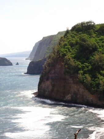
Figure 1. A series of valleys extend southeast along the eastern coast of Kohala. (Photo by Doug Faulkner)
|
A lookout at the end of Highway 270, which is at the top of a sea cliff, provides a fantastic view of the Pololū Valley below. The name Pololū translates from the Hawaiian language to “long spear” (Bishop Museum, 2011). The Pololū Valley is the northernmost of a series of valleys that lie along the windward east slopes of the Kohala Mountain in the district of North Kohala of the big island of Hawai‘i (Fig. 1). The Pololū trail, which goes down to the bottom of the valley, begins where the paved road of the highway ends. The topography transitions sharply from steep valley sidewalls to a relatively flat valley floor which lies close to sea level, about a mile long trail with about a 420 ft elevation difference between top to bottom. The slopes that boarder the valley increases in height gradually from downstream valley sidewalls towards the headwaters of an ephemeral stream. This is characteristic of these series of windward Kohala valleys and is a result of the headward-migrating canyon wall (Vitousek et al, 2010). At the valley bottom, the mouth of the valley consists of a black sand beach, bordered by wave-eroded and landslide-prone sea cliffs on its northern and southern, seaward sides. Tuggle and Tomonari-Tuggle (1980) offers a detailed description of the valley floor that is still relative to what is seen today: “Dominated by a sand dune…the mouth of Pololu extends some 500m wide [at the coast], with the stream outlet to the NW side. The valley floor extends inland for about 2500 m. at a 1 to 2 degree slope from a swampy area behind the dune to a small waterfall with plungepool, which separates the lower alluvial floor from an upper gulch. The lower valley has an area of some 100 ha.” |
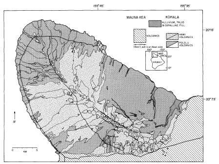
Figure 2. Geologic map of Kohala showing the Pololū and Hāwāi lava flows. (Map from Spengler, S. R. & Garcia, M. O. 1988)
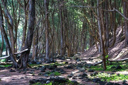
Figure 3. Ironwood trees that were planted during the 1950s on the slopes and peaks of the dunes in the Pololū Valley. (Photo by Beth Amann)
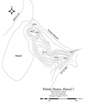
Figure 4. Map of Pololū Dunes with excavation units and sites indicated. Topographic contour on dunes 10 feet; highest point of dunes is approximately 50 feet. (Map from Field and Graves 2008)
|
Geology of the Pololū ValleyKohala Mountain, once an active volcano, last erupted around 120, 000 years ago. Valleys like Pololu were initially created by large, seaward landslides that occurred along the slopes of the Kohala Volcano, as evidenced by large areas of rocks and sediments that cover the nearby seafloor. The valley was filled in by lava flows during two eruptive episodes from the Kohala volcano (Fig 2). The geology of the valley and its surrounding uplands consists of tholeiitic basalts of the Pololū volcanic formation formed from eruptions dating back 400-600 thousand years before present (B.P.), and a more alkali Hāwāi formation basalts from eruptions that occurred 150-200 thousand years B.P. (USGS, 1998; C. M. Riley, 1980).
The Pololū DunesThe Pololū Dunes (noted as a single dune in Tuggle and Tomonari-Tuggle, 1980) located at the mouth of the valley lie directly above the beach (Fig. 3 and 5) and are estimated to be about 30 m above sea level at their highest part and extend 400 m parallel to the beach (Field and Graves 2008). The dunes are composed of eroded alluvial deposits which are argued to originate from discontinuous flood sequences of the ephemeral Pololū Stream. Wind and waves have pushed the dunes due southeast of the shoreline and have been altered by winter storm surges. According to Field and Graves (2008), these storm surges are said to be the reason for erosion on northern slopes and deposition of rounded, waterworn boulders and cobbles on the beach. Tsunamis have also morphed the landscape of the valley and most likely the dunes. In the 1950s ironwood trees (Casuarina sp.) were planted on the dunes’ slopes and peaks as a means to decrease erosion (Field and Graves 2008).
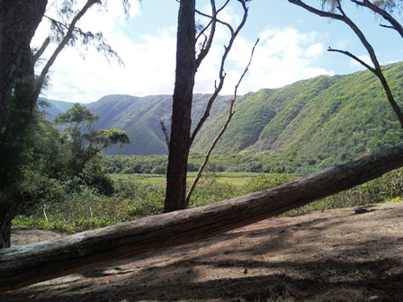
Figure 5. The dunes provide a barrier between the beach and the rest of the valley. (Photo by Lauren Roeglin)
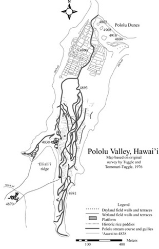
Figure 6. Map of Pololū Valley showing major archaeological sites and features. (Map from Field and Graves 2008)
|
Sources
Bishop Museum (2011). Weapons and Warfare. Hawai‘i Alive. Received from http://www.hawaiialive.org/index.php.
Field, J. S. & Graves, M. W. (2008). A new chronology for Pololu Valley, Hawai‘i Island: Occupational history and agricultural development. Radiocarbon, 50(2), 205-222.Maka o ka Aina (2011). Kako`i, adze-makers of Mauna Kea. Retrieved from http://www.mauna-a-wakea.info/maunakea/C_kakoiadazemakers.html.
Northwest Research Obsidian Studies Laboratory (2011). Hawaii fine-grained volcanic (FGV) toolstone source catalog. Retrieved from http://www.obsidianlab.com/fgv/fgv_catalog_hi.html.
Riley, C. M. (1980). Debris Avalanches, Landslides, and Tsunamis. Retrieved from http://www.geo.mtu.edu/volcanoes/hazards/primer/move.html.
Spengler, S. R. & Garcia, M. O. (1988). Geochemistry of Hawi lavas, Kohala Volcano, Hawaii. Contributions to Mineralogy and Petrology 99: 90-104.
Tuggle, H. , & Tomonari-Tuggle, M. (1980). Prehistoric agriculture in Kohala, Hawaii. Journal of Field Archaeology, 7(3): 297-312.USGS (1998). Kohala: Hawai`i's Oldest Volcano. Hawaiian Volcano Observatory. Retrieved from http://hvo.wr.usgs.gov/volcanoes/kohala/.
Vitousek, P., Chadwick, O., Hilley, G., Kirch, P., & Ladefoged, T. (2010). Erosion, Geological History, and Indigenous Agriculture: A Tale of Two Valleys. Ecosystems, 13(5), 782-793. doi:10.1007/s10021-010-9354-1
Banner photo by Doug Faulkner.
