|
Mamalahoa Hwy
Here we are looking at an 1801 lava flow from Hualalai and a 1859 flow from Mauna Loa (Refer to Figure 1). They both flow down the northwestern region of the island and even made it down to the ocean. You can also notice the differences between older lava (brownish red) and more recent flow (black/dark brown). Another distinguishing difference between the two is the amount of vegetation that is growing. The older flow has small trees (10 feet high) and smaller shrubs, while the newer flow is either bare or only holds small grasses. At this same location we introduced the words Mauka meaning towards the ocean and Makai meaning towards the sea. |
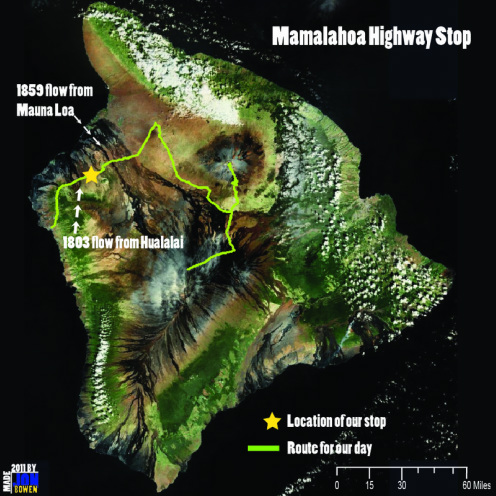
Figure 3. The Mamalahoa Hwy spans across Hualalai in the Western region of Hawai'i. It also intersects the 1801 flow out of Hualalai Volcano and the 1859 flow out of Mauna Loa. Map by Jon Bowen
|
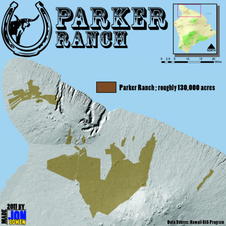
Figure 4. Parker Ranch is the largest ranch in Hawai`i. Map by Jon Bowen
|
On the Road
Along the way we noticed for the most part this lower-lying area is a dry savanna environment. This area as we were told later used to be thriving in low-lying shrubs and trees. A major factor to the decline of these savanna landscapes is due to feral cows and goats and one of the world’s largest ranches owned by the Parker family. History of the Parker Ranch A teenage sailor by the name of John Parker willingly stayed back on the island of Hawai`i after his ship left port. He eventually became friends with Kamehameha I, the king at the time, with his skill of the musket was allowed to shoot the cattle roaming around the Big Island of Hawai`i. According to the Parker Ranch’s website, John’s efforts for the cattle herd eventually replaced the sandalwood trade as the islands chief export. As generations went on the ranch exchanged hands of control through John’s sons, to family and friends, and eventually into the hands of Alfred Carter. Through Carter the ranch grew substantially and even served as a training camp (Camp Tarawa) in WWII for United States amphibious troops. The use of Parker of Ranch by the US military allowed the growth of parker Ranch to increase even more. “Parker Ranch and Waimea prospered economically with various support services. Electricity, a movie house, an ice plant and three reservoirs with a capacity of 14,000,000 gallons were brought to Waimea.” (Barros and Clark, 1995) What John Parker started in the early 1800’s grew to be the fifth largest ranch in the United States, covering 130,000 acres, and now holds over 15,000 cattle throughout the big island of Hawai`i. |
Kipuka Pu`u Huluhulu We arrived at 10:00 am ready for a snack and a short hike up the side of Kipuka Pu`u Huluhulu. The name of this site can be broken down into three different parts: “Kipuka” which means area surrounded or isolated by younger lava flows, “Pu`u” which is hill, and “Huluhulu” the name specific to the hill. This hill is actually a cinder cone feature that is at an elevation of about 6,500 feet above sea level, and is located in the saddle between the Mauna Loa and Mauna Kea volcanoes. This particular Pu`u was home to what is referred to as a “Cloud Forest”. As cloud bands pass through the area, the vegetation on the top and sides of the Pu`u, water vapor clings to plants, and as the water droplets gather, they fall to the ground to provide hydration to the plants. This is called occult or horizontal rainfall. These cloud or mountain forests are home to a wide variety of plant and animal life. This biodiversity on this isolated piece of land was described by many in our group as “an environment straight out of Lord of the Rings.”
|
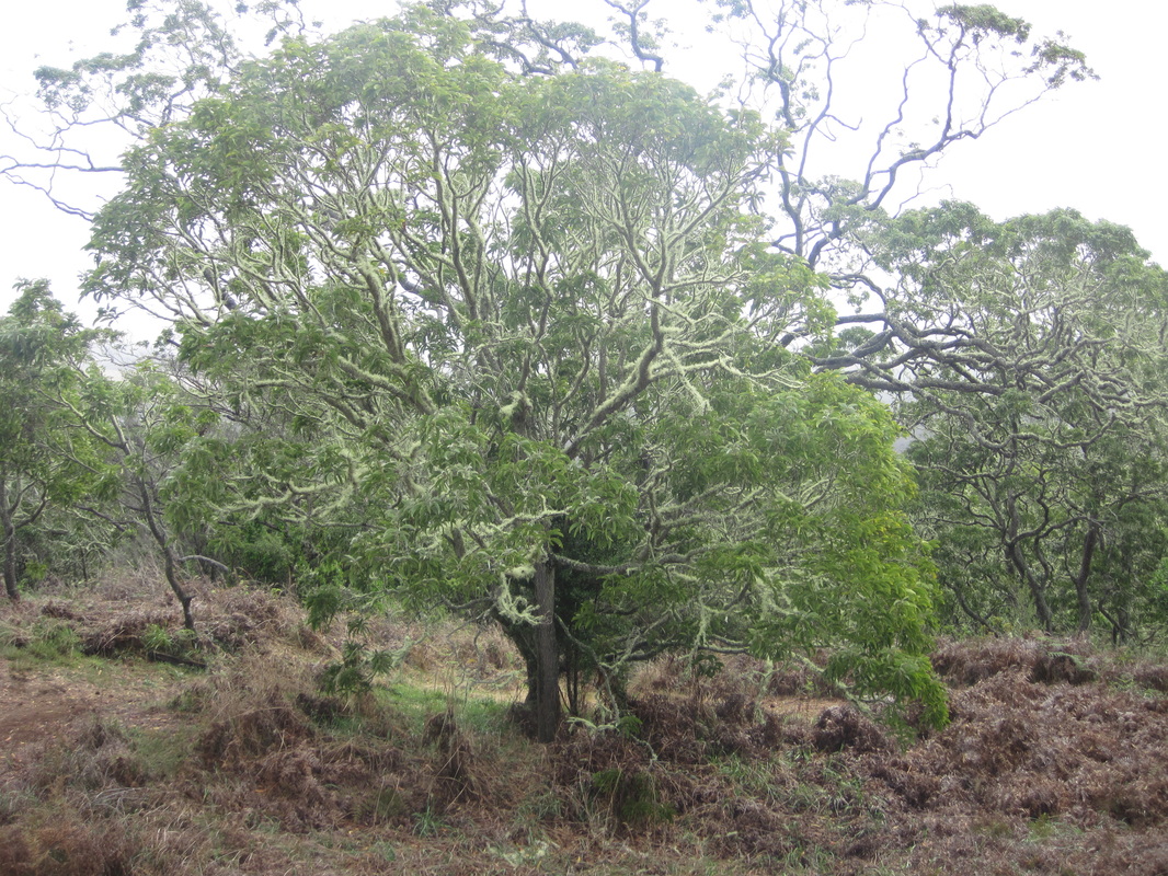
Figure 5. One of the many different types of tree found in the sanctuary. This is what was described as being one of the "Lord-of-the-Rings-esque" sights. (Photo by Doug Faulkner)
|
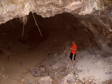
Figure 6. Our fellow classmate Beth peering into the depths of a Lava Tube. (Photo by Ross Auna)
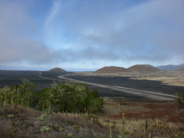
Figure 7. Excellent view of a past lava flow of Mauna Loa. Taken from the top of Pu`u Huluhulu. (Photo by Ellen Sorenson)
|
Lava Tubes Our next couple of stops included visits to some old lava tubes or caves, which were created by lava flowing through underground chambers. These lava chambers are home to some very unique geological and geographical features of which many of us have never seen before. For one, there was some sort of stalagtite formation that we as a class could not come up with a surefire reason for how they were all formed. One hypothesis was that lava was flowing through the tube, stuck to the cave ceiling, and began to drip and solidify. The stalactites themselves had salt deposits, smelled like water, and were damp/dripping, all pointing to the fact that there was moisture in the ground in this area. This moisture or excess of water could have been a factor that contributed to the rapid cooling of the lava that led to the formation of these stalagtites.
Also easily identifiable at these locations were the different rock types that littered the Pahoehoe and A`a lava flows. While the primary color of most of the rocks is black, there were many red rocks, as well as those that were brown and green. All of these rocks and minerals were of the Mafic classification. The term mafic refers to a rock that is rich in magnesium and iron. The rocks we were looking at were all basalt, with varying levels of things like iron and olivine content. Many of the more brown rocks contained lots of olivine, which was visible by the green crystals that were embedded in the rock. The black and red hues of the basalt were a result of the different levels of iron present. Rocks from older lava flows are more red or brown in color, while the dark brown or black rocks indicate the most recent lava flows. |
Sources
National Park Service. Hawai’i Volcanoes & Haleakala. Volcanoes of the National Parks of Hawaii. 2006. (http://www.nps.gov/history/history/online_books/hawaii-notes/vol4-2-7c.htm).
Holt, Kim. October 2009. “Parker Ranch: Maintaining the Legacy” ANGUS
Journal. Retrieved November 28th, 2011 (http://www.angusjournal.com/ArticlePDF/Parker%20Ranch%2010.09.pdf).
Barros, Aileen Lindsey and Clark, Alice. 1995. “Fiftieth Anniversary Commemoration of Camp Tarawa.” The Waimea Gazette.
February. Retrieved November 28th, 2011 (http://www.waimeagazette.com/Feb95_CampTarawa50th.htm).
Banner Photo by Jon Bowen
